
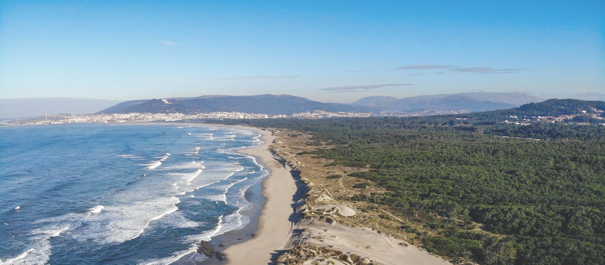
Faro de Anha climbing dunes


Local Natural Monument


GEOSITE
8
The formation of dunes by the wind
Dunes are landforms that develop from the movement of sedimentary particles driven by a fluid, usually air or water (Fig. 8.1).
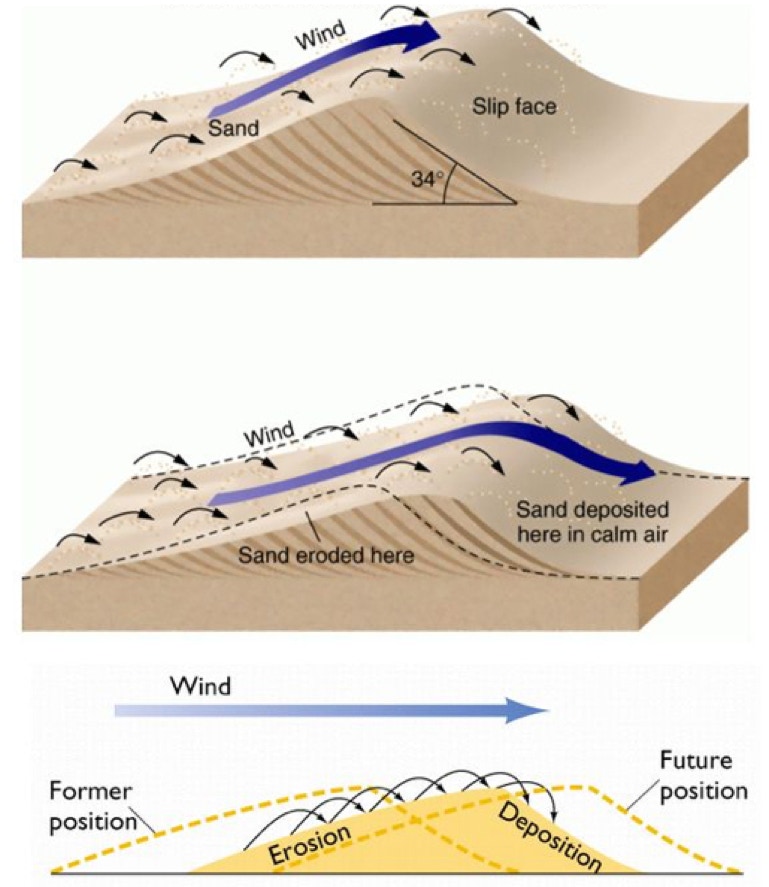
Figure 8.1. Typical shape of a sandy dune and its movement leading to its migration, downwind. Sand particles (between 2 and 0.063mm in diameter) are moved by the wind on a free surface.
The transport of sediments leads to the formation of rhythmic elevations with two faces. The windward face is less inclined and the opposite face is more inclined. The crest of the dune separates its two faces. Sediments are moved from the windward face to the opposite face. This continued action results in the dune migrating in the same direction of the prevailing wind. This migration continues as long as: i) the wind continues to blow; ii) there is enough supply of sand and; iii) there are no obstacles in the way the dune is migrating.
Wind-originated sandy dunes can be developed where sand can accumulate and migrate due to wind blowing with speed generally higher than 15 km/h. Wind dunes usually form in deserts or sandy beach. Regardless of whether the environment is cold or hot, dryness is an important condition for the wind to be able to transport sand particles, as water tends to cause it to stick, making transport difficult.
A typical sandy dune is between 3 and 100 meters high and is asymmetrical, with the windward face having a lower slope (between 10 and 15 degrees) and the opposite face with larger slope (30 to 35 degrees). On the face exposed to the wind, sediment is transported by creep (near the ground), by saltation or by suspension (aerial transport).
Sediments that move by creep often form small undulating structures called wind ripples (Fig. 8.2).

Figura 8.2. Duna arenosa apresentando ripples eólicos na face exposta ao vento.
Once the dune crest is crossed on the leeward face, most of the sediment will no longer be transported, precipitating and rolling over the dune face, thereby giving rise to a type of structure called foreset bed. Sometimes dunes can migrate over existing dunes. When the overlapping movement of several dunes occurs, another type of structure can form: the cross-bedding (Fig. 8.3).
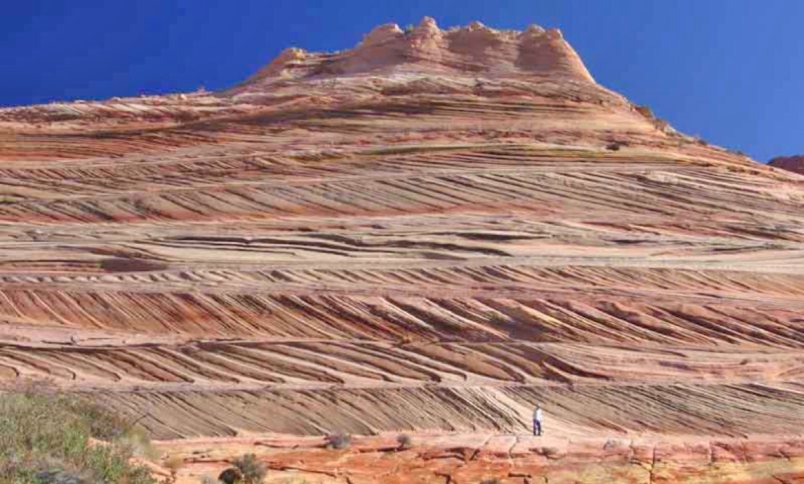
Figura 8.3. Estratificação dunar entrecruzada.
Between dunes interdunar depressions may form, where vegetation can grow and even small ponds develop. If this happens, dune migration may cease, but nothing prevents that if the wind carries sufficient sediment, the interdunar depressions may again be covered by sediment and dune migration will be reactivated.
Types of dunes
Regarding morphology, dunes may be classified into six major groups, based on the shape, number of faces, and wind direction (Fig. 8.4).
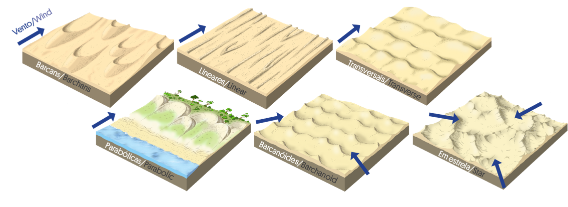
Figura 8.4. Ilustração de seis tipos comuns de dunas arenosas.
Transverse dunes form when there is plenty of sand. Viewed from above, these dunes have parallel or slightly curved ridges and align perpendicular to the prevailing wind direction. There is a close relationship between the height of the dune, its width and the space between ridges. The transverse dune sediments give rise to a cross bedding that is preserved at the same time as the dune migrates. Transverse dunes account for about 40% of existing dunes globally.
Linear dunes are formed in areas with limited sediment supply but strong wind. The elongated parts of these dunes are parallel to the wind direction. These dunes are usually less than 4 meters high, but can extend for several kilometres. In the wide deserts, for example, these dunes can reach 100m in height and 120km long.
Barchan dunes are formed in the absence of vegetation, with dominant wind with slight variations and limited sediment input. Barcans occur as isolated, crescent-shaped dunes with a well-marked concave face and horn-shaped tips that develop to leeward. If wind conditions are relatively constant, they can migrate long distances without significant changes in shape. Most barcans have a convex profile and their height is typically 1/10 of their width. If the sediment input increases progressively, the dunes barcans can progressively form barcanoid dunes or even transverse dunes. As in the transverse dunes, barcanoid dunes also give rise to cross-bedding. Barcans represent only a small percentage of dunes globally.
Parabolic dunes are common in most low coastal areas and sandy environments in semi-arid environments. Parabolic dunes are characterized by the U-shape in which the ends or tails of the dune that lie behind are parallel and partially overgrown. The most frontal part, also called the “nose” of the dune, advances further than these points. The conditions of formation of these dunes are not yet fully understood, but seem to be associated with the presence of moderately developed vegetation, a strong and predominantly unidirectional wind regime, and a reasonable sediment input. The parabolic dunes are reminiscent of the barcans dunes but with the ends pointing in the opposite direction. The dune can be anchored by vegetation.
Star dunes are characterized by their considerable size, in the order of hectares, pyramidal shape and radiant and curved tips or arms. The basal faces of the star dunes consist of a smooth and wide profile. They are the largest dunes in many deserts and can reach heights of over 300 meters. They usually have a higher volume of sand than other types of dune. These dunes are associated with locations with high sediment availability and varying wind directions, especially at the time of transport. They have a central peak with a pyramidal shape, from which radially extend several tips or arms, the whole having several faces.
In what concerns its mobility, dunes can be stationary or migratory. In stationary dunes, the sand settles in successive layers that follow the exposed profile of the dune, creating a stratified internal structure. Although, downwind of the dune, strong wind-generated turbulence may occur, the sand particles remain attached to the windward strata, which tends to block the movement of the dune. Increasing moisture, internal obstacles (rocky outcrops, logs, etc.), or vegetation may affect dune mobility.
In the migratory dunes, sediments move downwind and precipitate downwind, leading to dune migration. The intensity of this movement varies, depending on the intensity of the wind, the availability of sediment, the existence of obstacles, among others. Dune migration can cause problems, such as infilling of water bodies or burial of agricultural fields or built structures.
Fossil dunes
Fossil dunes are consolidated dunes or paleodunes, and represent a development stage after the dune formation and mobility (Figs. 8.5 and 8.6). This process may be short, corresponding to the consolidation of dunes due to absence of wind or water or by protection of the dune sediment by vegetation. In more advanced stages, which may last several thousand years, dune consolidation may occur, but maintaining the respective sedimentary structures. Such consolidation may be due to the formation of a carbonate cement resulting, for example, from the dissolution of fragments of shell constituents of the sand or from the percolation of carbonates carried by water.
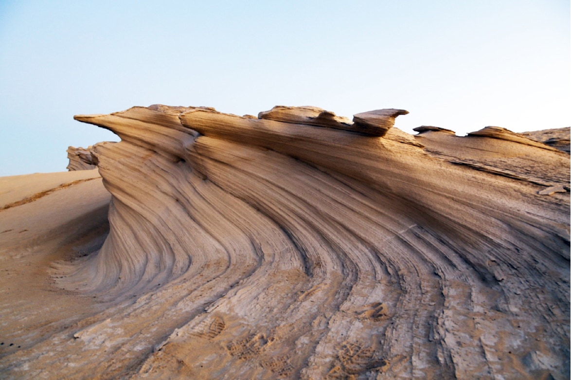
Figure 8.5. Fossil dunes at Al Wathba (photo of Vinayak Bhat).
Figure 8.6. Fossil dunes in Arizona, USA. Locally, these structures are known as “the wave”.
Formation and evolution of Galeão Dunes
The area south of Lima River, between the sea and Galeão Hill, is covered by a sandy deposit. The upper part of this deposit seems to have been deposited during a colder climate, known as the Little Ice Age that took place approximately between 1300 and 1850.
Although the causes for the Little Ice Age are still a matter of debate, it seems to have started due to volcanic activity and has been maintained due to low solar activity.
During the Little Ice Age, it is estimated that the sea was between 20 to 80 cm below the current level. During this period, it is very likely that, due to storms with heavy rain / snow, sedimentation increased along the river valleys, thus contributing to the supply of sediments in beaches. The abundance of sediments on the Lima River estuary was still visible in the year 1856, as it was represented in the map of figure 8.7. This map clearly represents a large amount of sediment in the riverbed beyond the Saint Lourenço Chapel, being the channel width considerably narrower than today (Fig. 8.8).
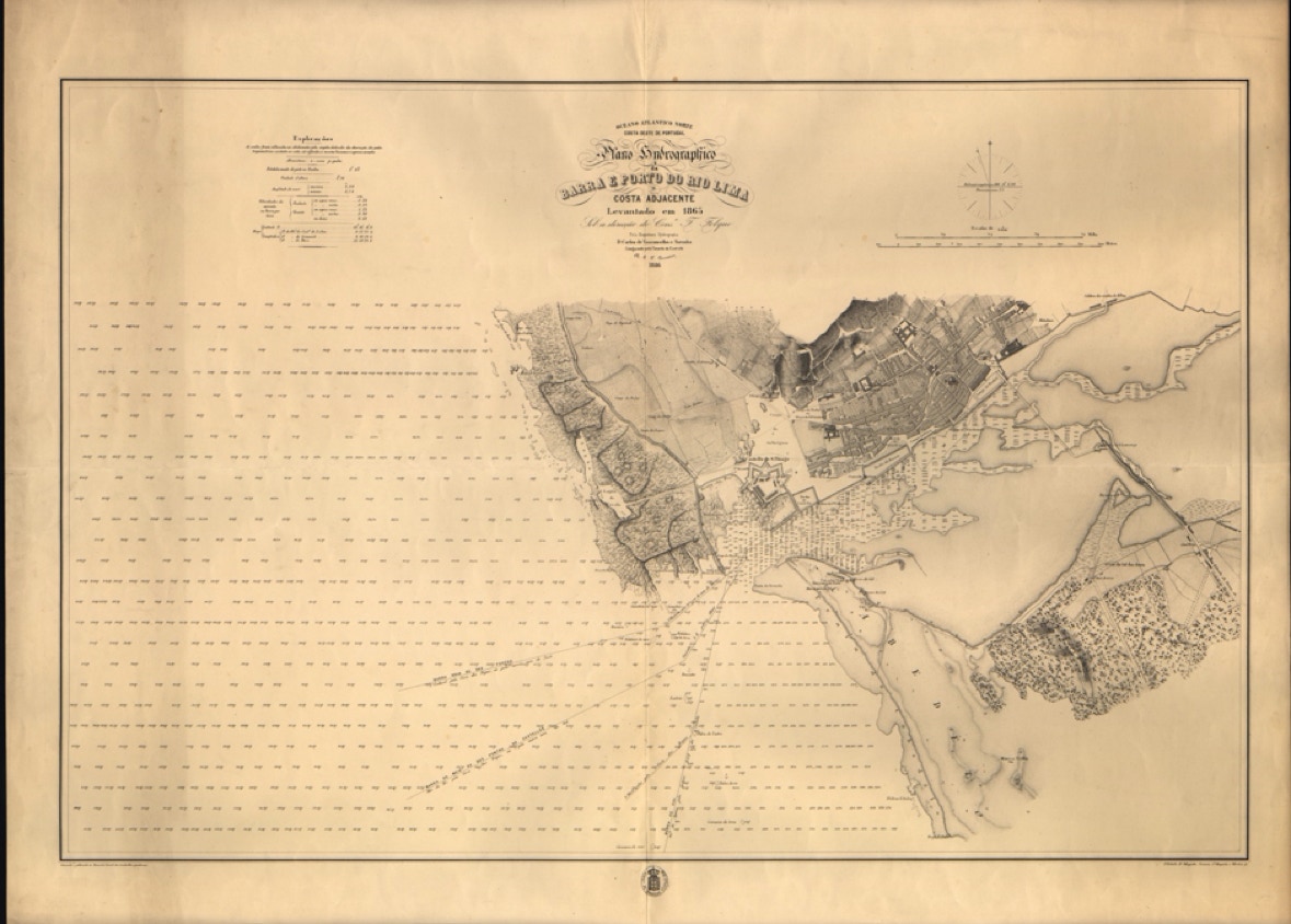
Figure 8.7. Map of Viana harbour, 1856.
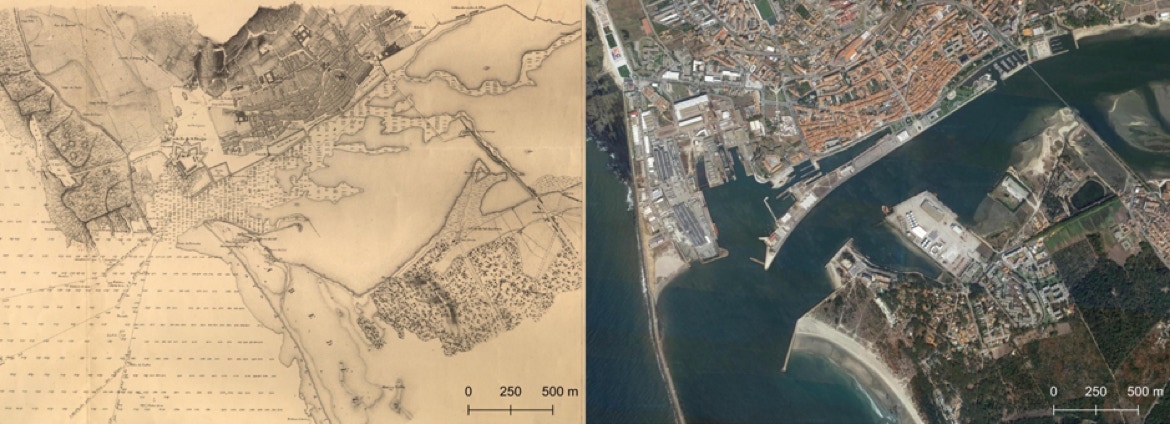
Figure 8.8. The mouth of Lima river in 1856 (left) and today (right).
The existence of narrow channels and the large amount of sediment in the riverbed are still visible in figure 8.9, which reproduces a photograph of the first decade of the 20th century, contemporary of the first phase of construction of Santa Luzia Sanctuary.
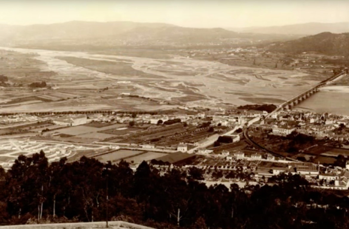
Figure 8.9. Lima river estuary in the first decade of the 20th century.
Figure 8.10 is a 19th century representation of the Lima riverbed, probably during high tide, and in which the sparse vegetation of the hills on the south bank of the river and extensive unforested white patches is visible.
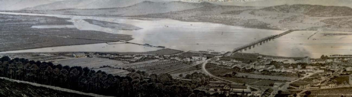
Figure 8.10. Lima riverbed in the 19th century (in Pires, 2005).
The sediments carried by the Lima River are deposited in coastal areas creating wide beaches. The abundance of sediment on the beaches and on the riverbed, coupled with strong winds that would have been felt during the Little Ice Age, will have allowed the mobilization of sediment that gave rise to extensive coastal dunes. Since sea level was then lower than at present, there has also been an increase in the area of the beaches, a circumstance that would have provided even more sand for the dune development. This context was fundamental for the formation of most recent dunes in the Portuguese northwest coast. The dating of samples taken from these formations fits this time frame, and the sediment was most likely deposited between the 16th and 19th centuries.
The Faro de Anha dunes resulted of the abundance of sediment combined with the morphology of the terrain, gently sloping to the top of Galeão hill, and the absence of obstacles to wind transport (namely vegetation) to form coastal dunes and climbing dunes.