
Poço Negro waterfalls


Local Natural Monument


GEOSITE
6

How Poço Negro waterfalls have formed?
Poço Negro waterfalls (Poço negro means black well) are located in Pêgo stream and are related to an old coastal cliff. The waterfalls are located in the most entrenched section of Pêgo stream (Figs. 6.1 and 6.2).
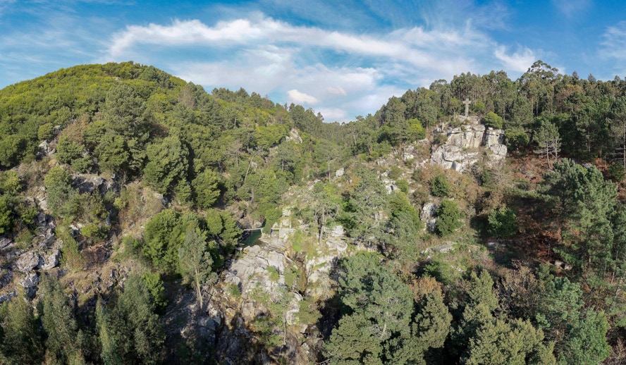
Figure 6.1. Poço Negro waterfalls in Pêgo creek.
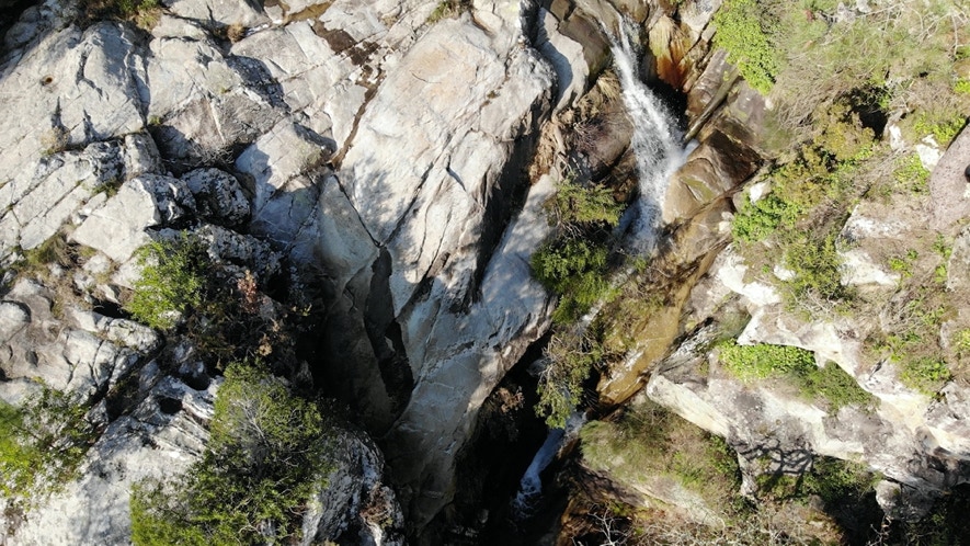
Figure 6.2. Aerial view of Poço Negro waterfalls.
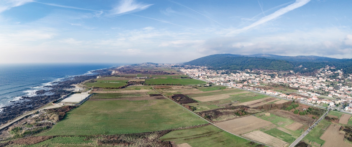
This section connects ancient higher erosion platforms (above 100 meters) with the actual coastal platform that is being formed (below 60 meters) (Figs. 6.3 to 6.5).
Figure 6.3. Poço Negro are located in the slope between the higher planes (right) and the coastal platform (left).
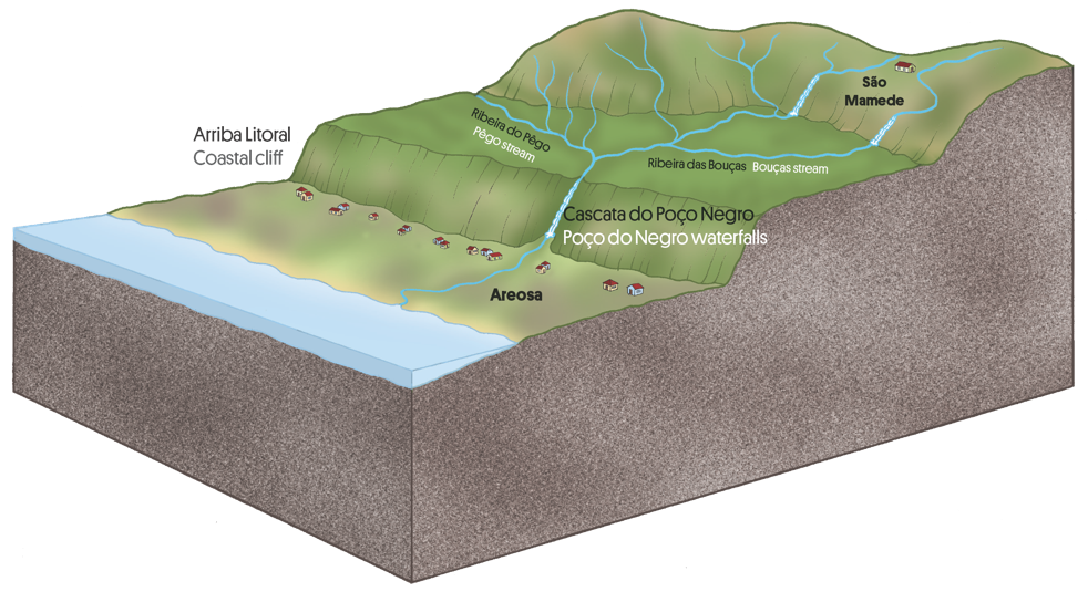
Figure 6.4. Location of Poço Negro waterfalls.
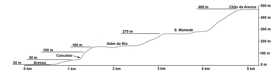
Figure 6.5. Longitudinal profile (Vertical scale is exaggerated) highlighting the sharp slope in Pêgo stream section and several erosion platforms located between Saint Luzia plateau and the beach (Carvalhido, 2012, O litoral norte de Portugal (Minho-Neiva): evolução paleoambiental quaternária proposta de conservação do património geomorfológico, tese de doutoramento, Universidade do Minho).
Cascades are a particular type of waterfall where the water comes down along a series of steps naturally excavated in the rock. Such is the case of Poço Negro Waterfalls. Their origin is related to the marked decrease in the average temperature of the Earth that took place about 2.5 million years ago. It was the beginning of a glacial period, the Quaternary, which is still ongoing. The decrease in temperature led to water retention in the form of ice next to the poles and in the mountains. As a consequence, there was a fall in sea level. Sea level fall in the western coast of the Iberian Peninsula was a determining factor in the origin of Poço Negro Waterfalls according to a process similar to the one depicted in figure 6.6.
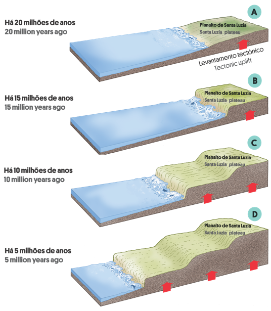
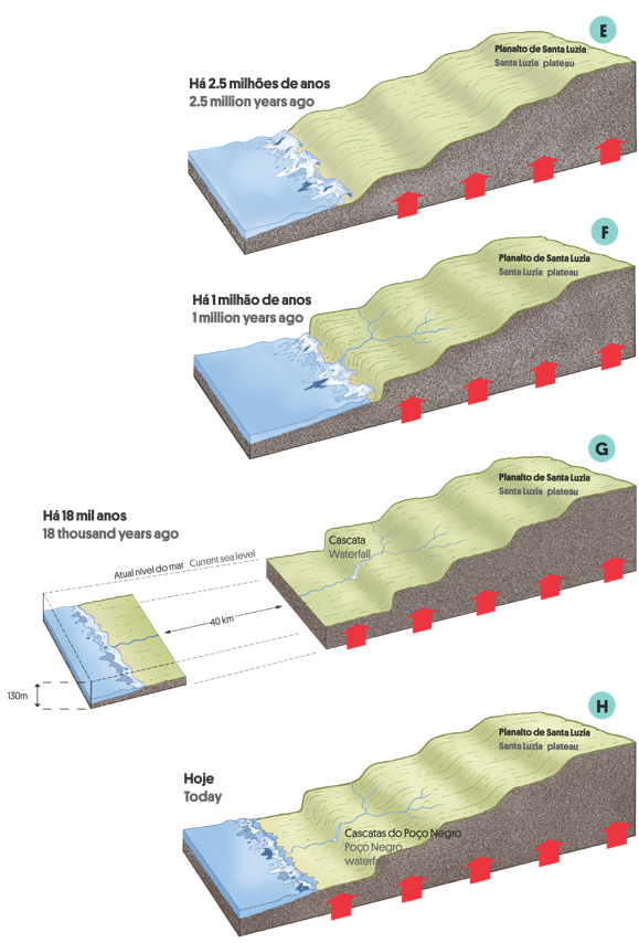
Figure 6.6. Evolution of Viana do Castelo north coast and origin of Poço Negro waterfalls (see explanations in the text).
A) About 20 million years ago, when climate was warmer than today, sea level was higher.
B) In the course of time, tectonics lifted the continent in relation to sea level.
C) As a consequence, several flattened surfaces were formed due to sea erosion.
D) About 2.5 million years ago, a period of global cooling occurred; as a consequence, sea level dropped.
E) At the same time, tectonics continued to lift the continent.
F) The fast sea level fall originated the costal cliff where Poço do Negro waterfalls are located.
G) Eighteen thousand years ago, sea level was about 130 meters below today’s level, and the coast line was 40 km from the current position. Since then, sea level has risen.
H) These waterfalls were formed due to a fast sea level fall and the consequent formation of a costal cliff.
The functional value of geodiversity: the example of water mills
For a long time, the use of mills played a key role in the life of rural communities. Mills may use two types of power wind or water that may be used in different ways. This circumstance is reflected in the upbuilding of the mills, in the regime ownership, and in their use.
In Alto Minho, watermills are the most common but in some places near the coast between Viana do Castelo and Esposende windmills can also be found. Nevertheless, the high amount of rain and the rough landscape favoured the existence of watermills (Figs. 6.7 and 6.8).
Sometimes, small semi-industrial facilities with commercial purposes appeared offering a number of services besides cereal gridding, such as wood sawing, flax maceration, river crossing. This circumstance favoured the trade with the opposite bank and turned the place into a crossing point for the local communities thus countering their isolation.
Watermills may have different types of architecture which fall into two major types: with a vertical wheel outside the building or presenting a horizontal wheel inside the building. The first are more common in plain areas and the second in mountains.
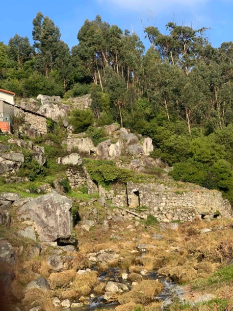
Figure 6.7. Watermills in Pêgo creek.
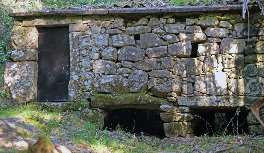
Figure 6.8. Watermill in Pêgo creek.
Usually, watermills with a vertical wheel are large masonry buildings with a gable roof. They are located on the banks of the final course of bigger rivers where the ground is flatter. The water of the river is dammed by a loose stone weir that directs it to a floodgate which in turn diverts the water so that it hits the blades of the wheel (Fig. 6.9).
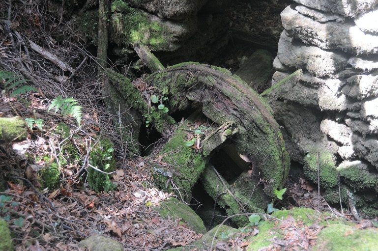
Figure 6.9. Vertical wheel of a watermill located in the Ferida Má waterfalls Local Natural Monument.
The “levada” is a channel that diverts the water from its bed leading it to the mill. After moving the caster, the water may return to its natural course, it can be diverted to other mills or it can follow downstream (Fig. 6.10).
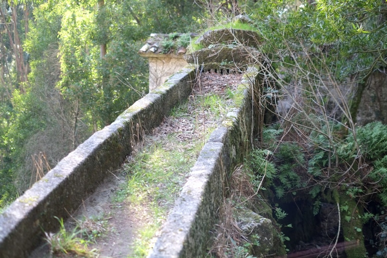
Figure 6.10. Levada in Poço Negro waterfalls.
Grinding takes place when cereal grain is crushed between two hard surfaces, the grindstones, which crush the cereal and turn it into flour. The mill replaces muscle strength by water or wind power thus allowing the existence of a continuous rotating movement (Fig. 6.11).
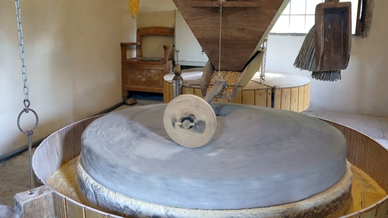
Figure 6.11. A rebuilt grindstone in a watermill in Poço Negro waterfalls.
In Poço Negro waterfalls, it is possible to see watermills with a horizontal wheel in small buildings covered by simple rooftops (Fig. 6.12). Here, the small dimension of the watermills is related to local conditions: a rough landscape with small streams where it is difficult to find a piece of land that enables the construction of big buildings.
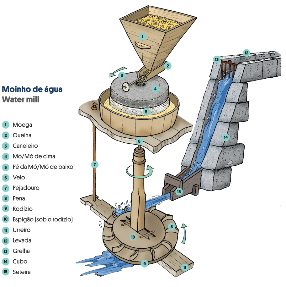
Figure 6.12. Different parts of a watermill in Poço Negro waterfalls.
The access roads to Poço Negro waterfall mills were handled by their owners. Cleaning, maintenance and construction of sidewalks facilitated the access. The mill worked day and night and sometimes shift changes took place in the middle of the night when access could be unsafe. Grooves dug by the wheels of the wagons that carried the cereal and flour can be seen in the pavement near Poço Negro watermills.