
Chãs de Arga Peat Bogs


Local Natural Monument


GEOSITE
3

Arga Mountain and its landforms
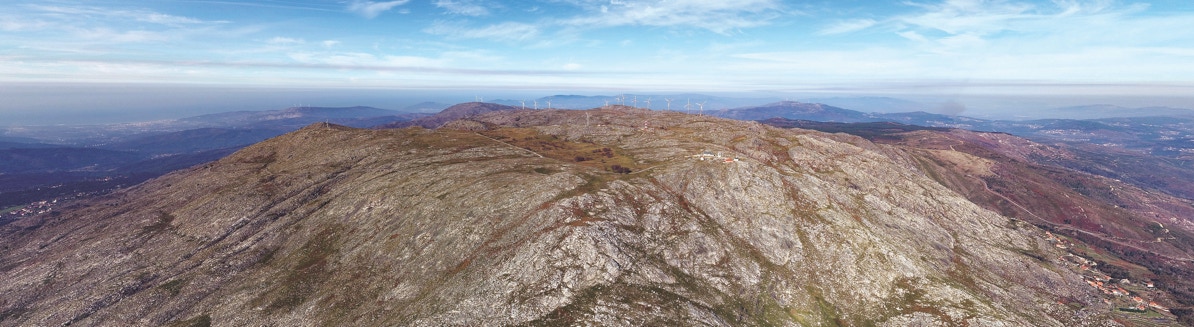
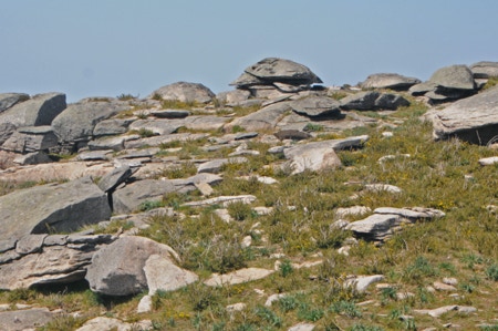
Arga Mountain plateau: a dramatic landform
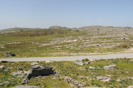
Arga Mountain has a plateau about 800 meters high, the same altitude as the one presented by the most regular and well-preserved rocky sectors of inner regions of the Iberian Peninsula.
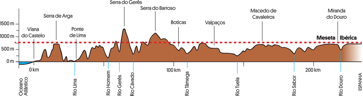
Figure 3.1. Arga Mountain plateau is a rare remnant of the surface of the Iberian Meseta, which reaches 800 meters, its highest altitude, in the inner part of the Iberian Peninsula.
The strong erosion in the region led to the formation of a vast flat surface near sea level about 80 million years ago (Fig. 3.2A). Afterwards, tectonics lifted the surface, known as the Iberian Meseta, to its current altitude. With time, part of the Iberian Meseta disappeared as a consequence of erosion and river incision. The flattened top of Arga Mountain is a remnant from the time when tectonics lifted the Iberian Peninsula to its highest altitude. Thus, Arga Mountain is a granitic residual landscape with a very particular meaning.
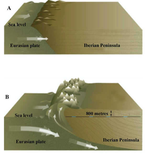
Figure 3.2. Simplified scheme showing the rise of the Iberian Meseta by tectonics.
Small landforms
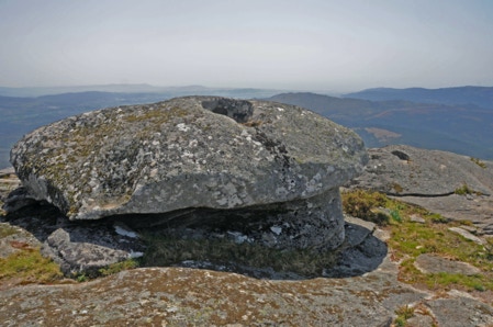
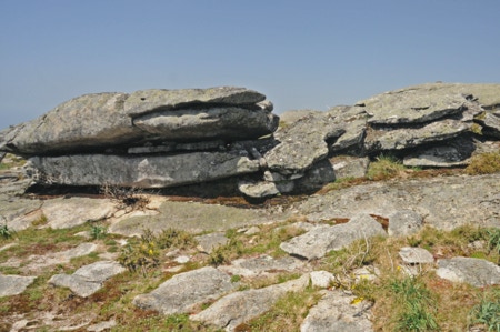
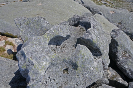
In the Arga Mountain plateau, and particularly in the area of the peat bogs, there are some small landforms whose origin is related to the prevailing rock type granite in this case , the fractures network, weathering, and erosion.
Weathering was particularly significant during subtropical or mild to hot climate that existed in the Iberian Peninsula until about 2.5 million years ago. This circumstance allowed the formation of granite blocks, castle kopje, tors, tafoni, linear joints, etc. that stand out in the landscape (Figs. 6.3 and 6.4) These landforms arose when large quantities of dismantled rock were removed while the surface was being lifted from where it was originally near sea level to its present altitude.
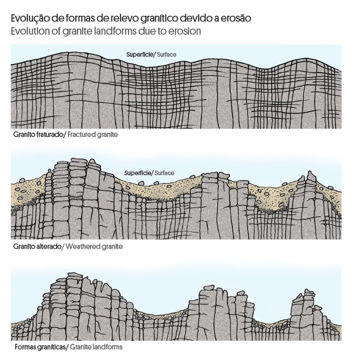
Figure 3.3. Evolution of granite landforms due to erosion.
The most striking aspect of the local granitic morphology is the development of pseudo-bedding, which is a type of sub-horizontal fractures (Fig. 3.4D). Pseudo-bedding isolates overlapping rock slabs which can present considerable gaps between them. These and other geomorphological characteristics, such as the development of small cavities and the existence of peat bogs, allow to consider that the landscape has evolved under periglacial climate conditions during the last 2.5 million years. During colder periods, successive temperature variations that originate ice and thaw cycles promoted rock fracturing.
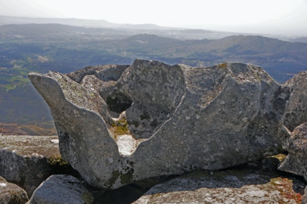

A
B
C
D
E
F
Figure 3.4. Small granite landforms in Arga Mountain plateau.
3.2. What is a peat bog?
Peat accumulates in shallow basins with a minimum depth of 30 to 40 cm known as peat bogs (Fig. 3.5). Peat, also known as turf, is a dark mixture of minerals and dead or partially decomposed plant remains. The ratio between these two components can be quite variable. However, the amount of organic matter is usually higher than the one existing in most soils.
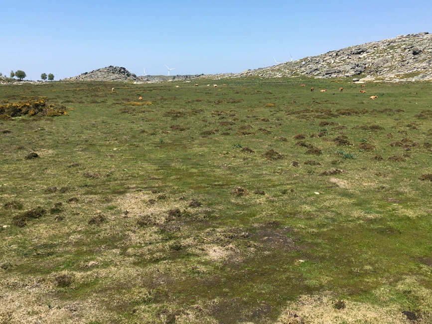
Figure 6.5. Chãs de Arga peat bog.
Where, how and when do peat bogs form?
Peat bogs originate in places where the water flows slowly or accumulates and where a diversity of characteristic plants, such as some species of mosses, reeds and shrubs exist (Fig. 3.6). In an acidic and anaerobic (poor in oxygen) environment, these plants do not decay completely, and their remains mix with minerals resulting from rock weathering originating the turf. As turf piles up, it retains water thus generating increasingly moisty conditions. In developing peat bogs, turf accumulates at a rate of about one millimetre per year.
Most peat bogs existing in mid to high latitude zones of the northern hemisphere were formed in the final stages of the last glaciation, about 11.700 years ago. After, as the Earth became warmer, peat bogs rather formed at higher altitudes.
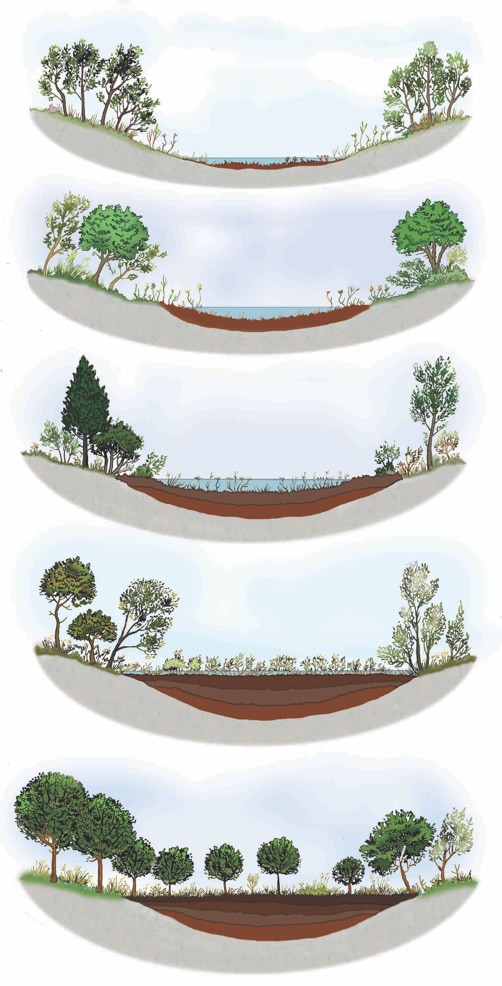
Figure 3.6. Development of a peat bog.
Peat bogs significance
The turf in a peat bog is an almost continuous record of sediments, plants, pollens, spores, animals, and even archaeological remains laid up in place or transported from surrounding areas, especially by the wind. It is an ‘archive’ in which the preservation of these elements enables the reconstruct the history of the local ecosystem. This ‘archive’ also provides valuable information about environmental conditions and changes in the last 10.000 years (Holocene).
Peat bogs are one of the biggest reservoirs of carbon (C) on Earth. Vegetable organic matter is largely made up of carbon that is taken from atmospheric carbon dioxide (CO2) by plants during photosynthesis. When plants die, their remains become ‘imprisoned’ in turf under moisty anaerobic conditions that prevent their complete decay and ensuing release of carbon. Once ‘captured’ in turf, carbon may be held for millennia.
Peat bogs may also influence microclimatic regulation because they promote the formation of dew, frost and haze. On the other side, there is a significant flow of CO2, methane (CH4), hydrogen sulphite (H2S), and nitrogen oxide (N2O) between the turf and the atmosphere.
Turf is an important energy resource; it is used as domestic fuel in several parts of the world. Such as other fossil fuels, turf is a non-renewable energy resource: its extraction rate largely surpasses the slow rate of turf accumulation, about 1 mm per year.
World distribution
Peat bogs have a large world distribution covering about 3% of land area which corresponds to more or less 60% of all the Earth’s wetlands (Fig. 3.7). Some of the largest peat bogs in the world include the western Siberian plain, the lowlands of River Hudson bay in the United States of America, River Mackenzie valley in Canada, and Tierra del Fuego peat bogs in Argentina.
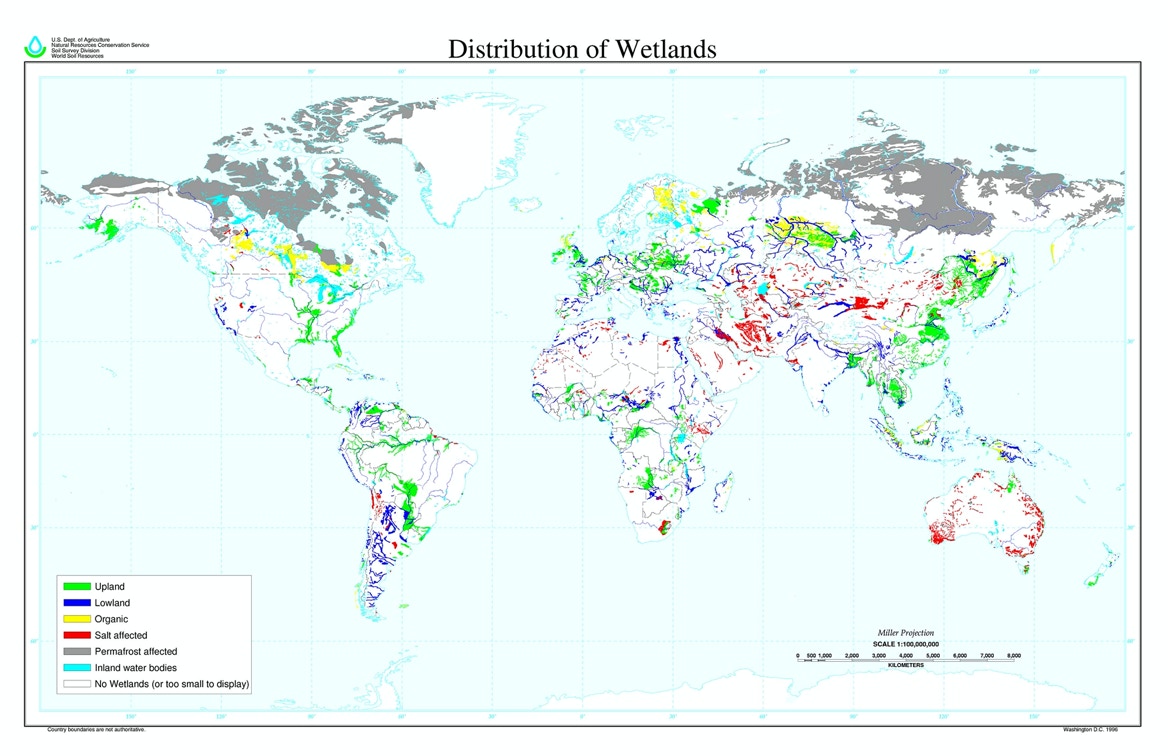
Figura 3.7. Distribuição mundial das zonas húmidas do planeta em terras altas e em terras baixas; 60% são turfeiras (https://www.nrcs.usda.gov)
Peat bogs in Portugal
Today, the area of peat bogs in Portugal is very small even if in the past their extension was significantly higher. Nowadays, peat bogs can be mainly found in mountain and plateau regions in the Northwest. They also occur in some places in Estrela mountain and in some other mountain areas in the South. In sublittoral regions, peat bogs may appear associated to flooded areas in the final course of rivers such as Minho, Lima and Sado, and from time to time with lagoons in ancient dunes, such as in the final part of Vouga river. There are also some peat bogs in the Azores and Madeira.
Conservation status of peat bogs in Portugal is usually low with some exceptions in the Peneda-Gerês National Park. Clearing of prehistorical forests by humans led to an increase in the area occupied by peat bogs in the Northwest of Portugal. Nevertheless, the more recent agricultural and pastoral expansion, the reforestation of the country and the drainage of lagoons and marshes as a measure to prevent malaria led to a marked decrease of peat bogs. Today, peat bogs are menaced by grazing, trampling, drainage, and the use of fire.
Careful management of the present areas occupied by peat bogs implies control of grazing, interdiction of trampling and drainage, and the implementation of protected areas. The restauration of deteriorated peat bogs that may still be recovered must also be promoted.
Chãs de Arga peat bogs
Chãs de Arga peat bogs occupy an area of 591 hectares in the same place where Âncora river is born (Fig. 3.8). These peat bogs are part of the so-called ‘Atlantic peat bogs of the mountains of the Iberian Northwest’. The most ancient might have been formed 10.000 years ago but many of them are much younger, 2000 to 3000 years old.
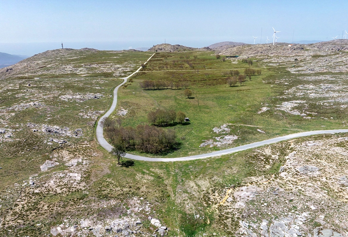
Figure 3.8. Chã Grande peat bog is the largest peat bog in this LNM.
The interpretation of the GPR profiles carried out in Arga Grande peat bog allowed to understand its stratigraphy with some accuracy.
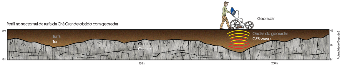
Figure 3.9. The geophysical survey with Ground Penetrating Radar done in the central area of Arga Grande peat bog identified the base of the peat bog at an average depth of 1.2 m, ranging from a minimum of 40 cm at the edges to a maximum of 180 cm at about 170 m from the beginning of the profile.
Mineral dating and the analysis of pollens preserved in the Chã Grande peat bog provided information on climate evolution of Northwest Iberia for most part of the Holocene, the geological epoch in which we are living during the last 11.700 years (Fig. 3.10).
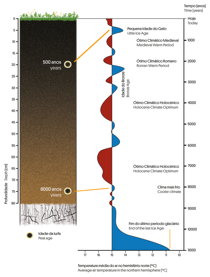
Figura 3.10. Relação aproximada entre a estratigrafia do perfil da turfeira da Chã Grande e a variação da temperatura média no hemisfério norte durante os últimos 11.000 anos, baseada nas datações e nos conteúdos polínicos.
In the beginning of the Holocene, climate was colder and herbaceous vegetation prevailed. Trees and shrubs existed only in protected places but as temperature rose, they began to expand, particularly Quercus robur. Shrubs developed mostly in higher places. During the Medium Bronze Age, shrubs diversified due to the escalation of agriculture and grazing with Quercus robur diminishing and Asphodelus augmenting.
In the last 500 years, a series of changes in the landscape took place due to the growing presence of man. In the 17th century, species like Quercus robur and Corylus avellane diminished; at the same time, the number of heather and grass increased. This circumstance might be related to the massive exploitation of the local forest arising from the development of shipyards in Caminha and Viana do Castelo coastal areas. In the final years of the 17th century and during the 18th, pine trees developed as a consequence of the expansion of forest plantations. In more recent times, there is a decrease in pine trees and a marked increase in eucalyptus and grass.