
Ferida Má Waterfalls


Local Natural Monument


GEOSITE
2

Cascades and other types of waterfalls
A waterfall is a sudden break in the slope of a riverbed. In what concerns the shape, there are various types of waterfalls: cascades, cataracts, plunge, block, punchbowl, among others (Fig. 2.1).
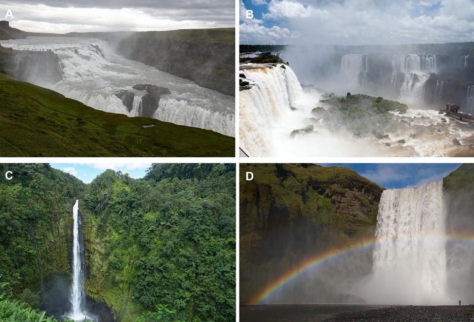
Figure 2.1. Examples of different types of waterfalls: A– Cascades (Iceland); B– Cataracts (Brazil/Argentina); C– Plunge (Hawaii); D– Block (Iceland).
A cascade is a particular type of waterfall presenting several steps naturally excavated in the rock which are originated by water erosion.
Cataracts are typically wider than tall and discharge a large volume of water. The Victoria Cataracts in the Zambeze river, and the Iguaçu Cataracts in the river with the same name that separates Argentina from Brazil, are two good examples of this kind of waterfall. Both are in the UNESCO’s World Heritage List.
In plunge waterfalls, water falls without contacting the rock such as in ‘Salto Ángel’, the world’s highest waterfall (979 m) located in the Canaima National Park in Venezuela. Salto Ángel’ is also as World Heritage by UNESCO.
In block waterfalls, the rock surface from which the water falls is wide such in Niagara river, in the border between the State of New York (USA) and the Ontario Province (Canada).
In a punchbowl, the water goes down along a narrow channel and is collected in a basin.
How waterfalls form?
The sudden break in the slope of a riverbed – waterfall – is associated with erosion which is related with certain characteristics such as (Fig. 2.2):
• the different strength of the rocks;
• the occurrence of faults and other tectonic movements;
• sea level changes;
• the melting of glacier ice.
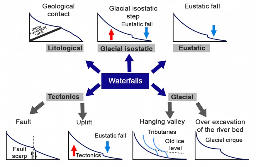
Figure 2.2. Main types of waterfall formation . Curved lines represent the river course from its source to its mouth. (modified from Castillo, M. y Lugo-Hubp, J. (2011). Estado actual del conocimiento, clasificación y propuesta de inclusión del término knickpoint en el léxico geológico-geomorfológico del español. Bol. Soc. Geol. Mex, vol.63, n.2, pp.353-364.)
Thus, according to their formation, waterfalls can be categorised as follows (Table 2.1).
Table 2.1. Types of waterfalls based on their formation (Castillo, M. y Lugo-Hubp, J. (2011). Estado actual del conocimiento, clasificación y propuesta de inclusión del término knickpoint en el léxico geológico-geomorfológico del español. Bol. Soc. Geol. Mex, vol.63, n.2, pp.353-364.).

Glacial waterfall
In mountainous areas shaped by glacial erosion, topographic contrasts in riverbeds are common, originating waterfalls. These waterfalls are inherited landforms of river processes as a result of differential excavation of the riverbed by the action of ice or sediments, or due to hanging valleys (Fig. 2.3). In the latter, the fall of water that forms after the retreat or disappearance of the glacier results from the lower erosion capacity of a tributary valley relative to the main valley.
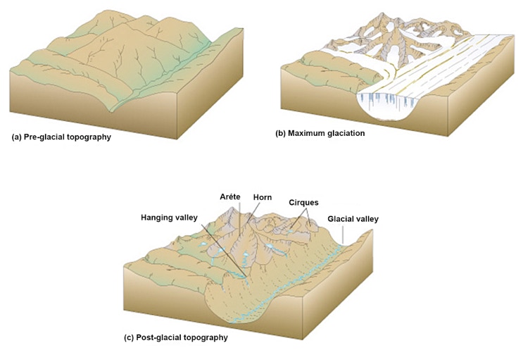
Figure 2.3. Waterfall related with hanging valleys of glacial origin.
Examples of glacial waterfalls include: Yosemite Falls, a set of three waterfalls in Yosemite National Park in Sierra Nevada, California, the highest waterfalls in the United States of America; the Gullfoss, also known as Golden Falls, which is Iceland's most popular waterfall located in a canyon fed by the Langjökull glacier, Europe's second largest glacier. In Portugal, one example are the waterfalls in hanging valleys connected with the glacial valley of Zêzere river (Fig. 2.4).
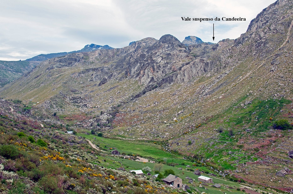
Figure 2.4. Waterfall at the confluence of the Candeeira hanging valley over the Zêzere glacial valley.
Lithological waterfall
The lithology (rock type) and the structures that affect it (e.g. faults, fractures) are a component of the landscape that is shaped by river erosion. The resistance to erosion is the main factor that may trigger the formation of a waterfall. In a contact zone between different rocks, the river erodes softer rocks faster than the more resistant ones. Thus, this differential erosion creates a waterfall.
The lithological structural control is evident in a horizontal, inclined or even vertical sequence of soft and resistant rock layers. The slopes in the riverbed are steeper in the more resistant layers (Fig. 2.5).
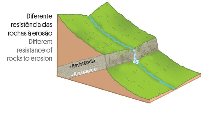
Figure 2.5. Illustrative scheme of a waterfall formed due to rocks with different resistance to erosion.
Tectonic waterfall
There are two mechanisms associated with tectonic activity that may originate waterfalls: faults and tectonic uplift (Fig. 2.2). A fault in the riverbed may provoke a sudden fall in the base level of the river basin, leading to the formation of a waterfall (Fig. 2.6).
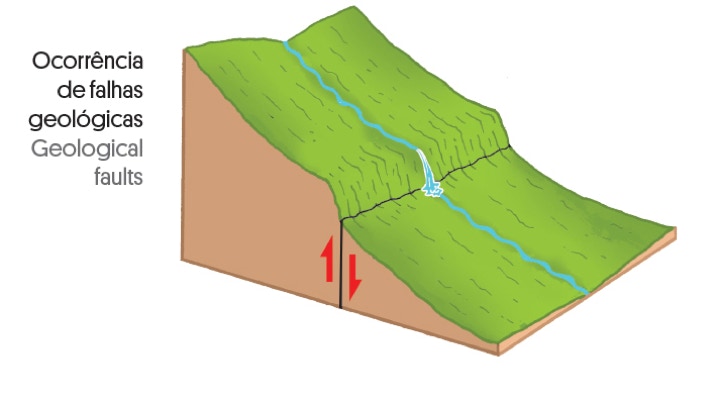
Figure 2.6. Schematic representation of a waterfall caused by a vertical fault.
Under equilibrium conditions, tectonic uplift is compensated by erosion. However, the increase in tectonic activity over a certain geological time interval may induce an imbalance by lowering the base level of rivers and consequently forming waterfalls.
Eustatic waterfalls (sea level fall)
The mean sea level defines the location of the river mouth, which marks the endpoint of the river erosion. Although sea level fall is responsible for the formation of waterfalls (Fig. 2.7), usually it is not an isolated event. Sea level fall may be related with an increase of tectonic uplift (see tectonic waterfall), a dramatic climate change (glaciation), increase of rock erosion or ice melt, or a combination of some of these phenomena. The association of waterfalls with eustatic changes should only be made if there are no signs of other processes that might justify the waterfalls.
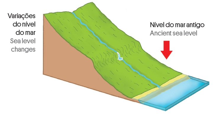
Figure 2.7. Formation of waterfalls due to sea level fall.
2.2. How Ferida Má waterfall have formed?
Ferida Má waterfalls are located along a 2.25 km section of Âncora river, between Montaria and Amonde. This section has a high steep slope (7.6%) and is about 10 kilometers from the river mouth (Fig. 2.8).
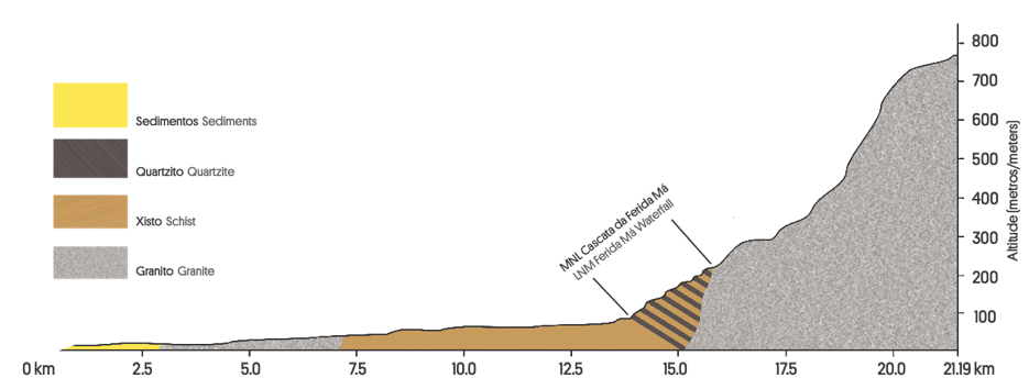
Figure 2.8. Âncora river profile and location of Ferida Má waterfalls.
After an initial section excavated in granite with a sharp but regular profile, the river crosses dozens of schist and quartzite layers arranged perpendicular to the bed, with different resistance to erosion. Therefore, the riverbed has numerous ridges originating rapids in this section of the river with several waterfalls sometimes with more than 5 meters high.
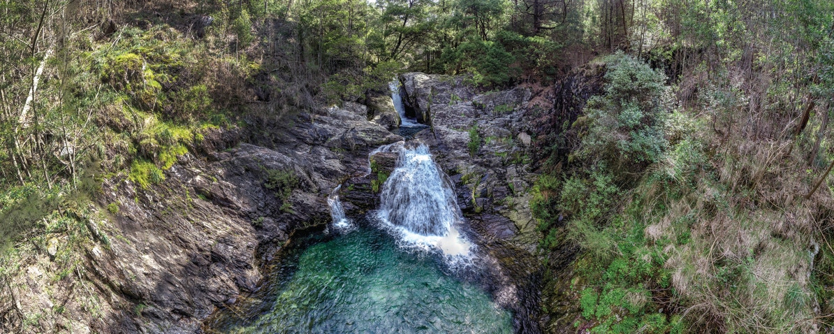
The most popular falls are also known as Pincho cascade, located along a succession of quartzitic layers (Fig. 2.9).
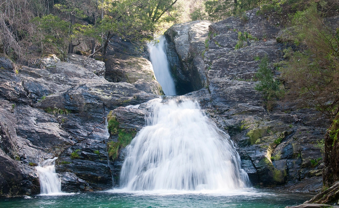
Figure 2.9. Ferida Má waterfalls, also known as Pincho cascade.
Thus, Ferida Má waterfalls are essentially due to lithological aspects related to the erosion resistance of metamorphic beds, as well as their orientation. However, the shape and slope of the riverbed were also influenced by sea level changes and tectonic uplift. The continuous increase in the difference of altitudes between the mouth and the river source, due to sea level fall to continuing tectonic uplift of the continent were a decisive factor in revitalizing the river erosion in the search for a new equilibrium profile.
Ferida Má waterfalls can be easily explained as an example of lithological waterfalls. However, in a more detailed and complete interpretation, processes of eustatic and tectonic nature must also be taken into account.